Canoe and Kayak Trails
All visitors,16 YOA or older, to the Eglin reservation must have an Eglin permit and photo ID.
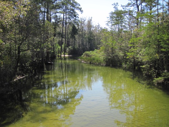
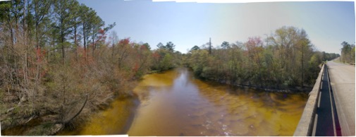
The watersheds of Eglin Air Force Base contain over 186 miles of steep-head streams and the waters and tributaries of the Yellow, Shoal, and East Rivers. These waters are often used for canoeing, kayaking, stand-up paddleboarding (SUP), swimming, and shoreline picnicking. These streams are characterized by an arching canopy of Titi, Cypress, and Bay trees overhead, and a soft, white sandy streambed underneath. The pristine waters well up from the Okaloosa Aquifer and maintain a 73○ F temperature, year-round.
Turkey Creek
(photo courtesy of the Emerald Coast Paddlers)
Trip Planning - Paddle trips on Eglin should be planned in advance. Accessibility of Eglin waterways will vary depending on daily mission closures. Areas of Eglin are subject to closure without advanced notice to the public. Visitors should always check the public access map PAM when planning a trip to the Eglin reservation.
Some pre-trip planning points to consider when planning a paddling trip:
- File a Float Plan with someone who will notify others if you don't return on time.
- Know the waters to be paddled. This guide/maps and other available references, such as online trip reports, are valuable in trip planning.
- Set up a shuttle for your desired trip. Plan to have dry clothing at your take-out vehicle. Calculate the distance and anticipated time of your trip. Consider stops and a lunch break, along with put in and take out locations.
- Many of the shuttle routes on Eglin require 4WD vehicles. Dirt road conditions on Eglin may become very challenging after heavy rain.
- Note that you must be off of the Eglin Reservation no later than two hours after sunset.
- Equipment - What you take with you on a trip is all that you have to survive and rescue yourself. This includes water, food, maps, rescue equipment, communications devices, and extra clothes.
- Paddle within your, and your group's, abilities and limits. Eglin’s paddle trails are all extremely remote.
Equipment - In addition to these points, you should consider your equipment needs. The following items are merely suggestions of the basic equipment needs for a trip to Eglin’s paddle trails:
- Proper Eglin permit and photo ID (in a waterproof bag or saved to your phone)
- Kayak/Canoe/SUP
- Paddles (one per paddler, plus one spare)
- Personal flotation devices (PFD’s, one per paddler)
- Food
- Water
- Sunscreen and lip balm
- Hat
- Sunglasses
- Rain gear
- Moisture-wicking (synthetic) clothing
- A cellphone (in protective bag or case)
- Waterproof watch
- Durable footwear
Paddle Trail Guidelines -
- Certain areas are shown on the trail maps as “Closed Areas.” Entry into any closed area is prohibited. Some streams mark the boundary of a closed area. Paddlers should exercise great care in not stopping on the restricted bank of these streams.
- PLEASE pack out all the material/waste/trash that you pack in.
- NO GLASS or ceramic containers are allowed along paddle trails.
- Camping is only allowed at designated campsites with the proper permit.
- Campfires along paddle trails are only allowed at designated campsites with the proper permit.
- All occupants of the vessel must have and wear a properly fitting personal flotation device when paddling on Eglin.
- NO PETS are allowed on any Eglin paddle trails.
- All Eglin waterways have ALLIGATORS. Swim and paddle cautiously.
Basin Creek
Located in Eglin’s Southwest corner and winds down through Basin Bayou to Choctawhatchee Bay, offering both a challenging or leisurely canoe trip in a relatively short amount of time. Along the banks, there is an abundance of red maple trees, which form small canopies of shade overhanging the creek.
Because of the heavy vegetation that Basin Creek passes through, there are not many cleared areas for rest stops. Areas for swimming are also very limited. However, the channel, which connects Basin Bayou with Choctawhatchee Bay, is an excellent swimming area.
Click on the image to see a larger map:
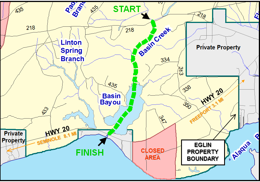
| Start: | Bridge on RR 218 |
| Take-out: | Bridge on Hwy 20 |
| Distance: | 2 mi |
| Estimated Time: | 2 hrs |
| Stream/River Width: | 15-50 ft |
Boiling Creek
Located in the Northwest corner of Eglin Range, Boiling Creek’s clear waters and pristine white sands twist to their eventual confluence with the Yellow River. Herons and small alligators are a common sight on Boiling Creek’s lower reaches.
Near the confluence, with the Yellow River, a large cleared area on the river-left is called “Rope Drop.” This was originally an old homestead but is now used by Army and Navy teams for special warfare training. About 30 minutes paddle downstream, Boiling Creek empties into the Yellow River. Paddlers may take out at RR 787 or continue on the Yellow River.
If continuing onto the Yellow River, proceed downstream to the boat ramp on the upstream, river-left side of the HWY 87 Bridge.
Click on the image to see a larger map:

| Start: | Bridge on RR 211 |
| Take-out: | Bridge on Hwy 87 |
| Distance: | 5 mi |
| Estimated Time: | 3.5 hrs |
| Stream/River Width: | 15-70 ft |
East Bay River Located in the Southwest corner of Eglin Range, the East Bay River has many deep holes and its black waters maintain a slow meandering current. The river width increases to about 100 feet while passing through the East Bay River swamp. There are numerous low-hanging branches but very few snags.
To reach the starting point of the canoe trail, go 4.3 miles west of the Hurlburt Gate and turn north on the road to Site A-21. Continue to the first bridge, which is Wells Crossing.
No overnight camping is permitted. The north side of the paddle trail is a restricted area. The river is bordered by private property on the south side for the final three miles. Exercise special caution to avoid trespassing and littering on this section of the trail.
Continue downstream to the bridge on HWY 87. The takeout is a boat ramp on the North (river-right) side of the HWY 87 Bridge.
Click on the image to see a larger map:
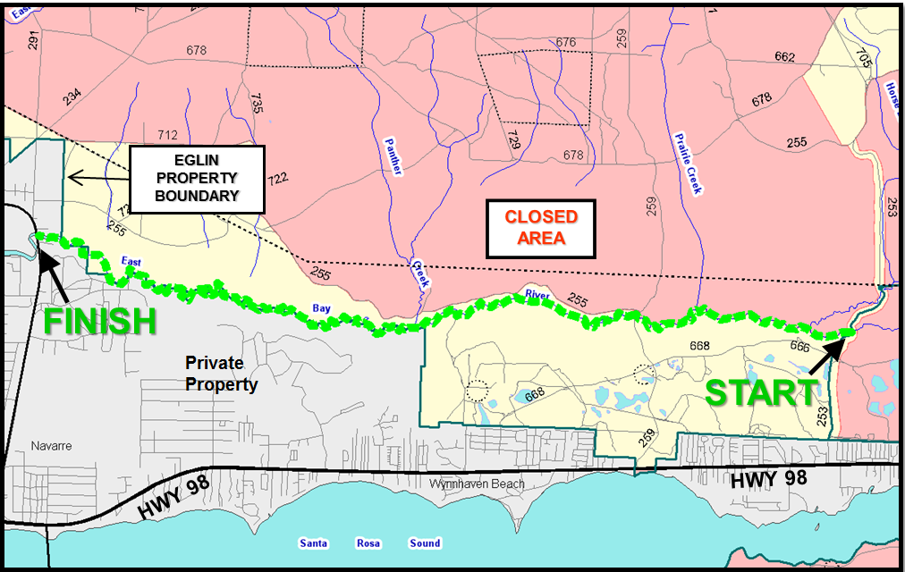
| Start: | Bridge on RR 259 |
| Take-out: | Bridge on Hwy 87 |
| Distance: | 6.05 mi |
| Estimated Time: | 6.5 hrs |
| Stream/River Width: | 15-100 ft |
Rocky Creek
ATTENTION: Current condition of the upper portion of this paddling trail (from RR200 south to RR219) is unknown. Paddlers planning to float this stretch should be prepared to portage around possible obstructions and blowdowns. However, the portion of this paddling trail south of RR219 should be mostly clear and require relatively few portages.
Rising deep within restricted areas, Rocky Creek is a blackwater stream that winds through some of the Eglin’s reservation's most pristine hardwood forests. Fallen trees are ABUNDANT and challenging obstacles. Rocky creek experiences some of the highest gradients on Eglin, making for a very fast current.
Heading downstream, School House Branch Creek enters from the east. When Little Rocky Creek enters from the west, the width and depth of the main channel increase. The bridge at Reservation Road 219, called “Mud Landing,” offers a nice place to stop for lunch or rest.
Caution: Before Rocky Creek enters Rocky Bayou, it spreads out into a swamp, losing its central channel, and branching into many confusing channels. Follow the strongest areas of current to maintain downstream direction. Tip: throw a leaf into the water and watch its movement to orient yourself to downstream flow. Rocky Creek flows approximately due West in the swampland section.
Click on the image to see a larger map:

| Start: | Bridge on RR 200 |
| Take-out: | Bridge on Hwy |
| Distance: | 6.3 mi |
| Estimated Time: | 6.5 hrs |
| Stream/River Width: | 15-25 ft |
Shoal River
Alternate take-out:
Forming the northern boundary of Eglin Range, the Shoal-Yellow River Trail winds through both Okaloosa and Santa Rosa counties before entering Blackwater Bay. Juniper, Oak, Gum, and Cypress dominate the forest along this 34-mile trail. It is important to note that on weekends these sections of the river are frequented by motorized watercraft operating at high speeds. Always keep close to banks to avoid collisions.
Field 6 (Ranger Camp) Landing is approximately 15 miles from Cox Bridge (HWY 85). Look for bleachers on the south bank of the ing. This stop can also be reached by car by traveling 12.2 miles west of Highway 85 on RR 211. Then proceed north on the first dirt road east of Camp Creek until the Yellow River.
Campsites
Camping Permit Required
Gin and Little Gin Campsites -- located approximately 2 hours from put-in
Carr Landing—located 3.5 hours from put-in
Metts Bluff—located 4 hours from put-in
Final take-out:
The take-out ramp is on the upstream, river-left side of the HWY 87 Bridge.
Click on the image to see a larger map:
| Start: | Bridge on Hwy 85 |
| Take-out: | Bridge on Hwy 87 |
| Distance: | 34.3 mi |
| Estimated Time: | 25 hrs |
| Stream/River Width: | 60-100 ft |
Shoal-Yellow Trail 1st LEG Highway 85 to Little Gin Hole Boat Ramp
Click on the image to see a larger map:
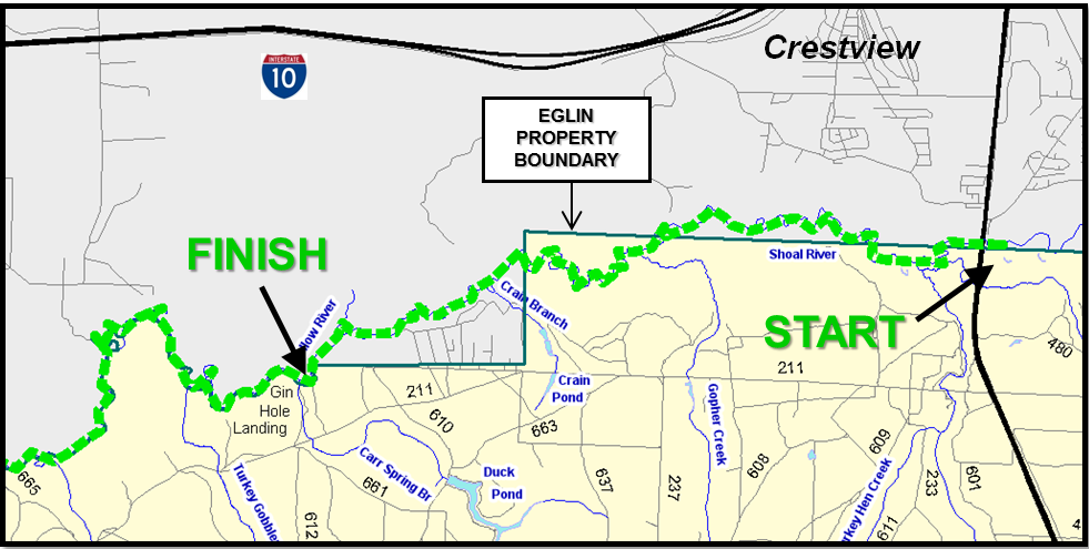
| Start: | Bridge on Hwy 85 |
| Take-out: | Boat Ramp Little Gin Hole Landing |
| Distance: | 7.2 mi |
| Estimated Time: | 6 hrs |
| Stream/River Width: | 60-100 ft |
Start: Cox Bridge, Hwy 85 South of Crestview
Take-out: Boat Ramp, Little Gin Hole Landing, North of RR 211
Distance: 7.2 mi
Estimated Time: 6 hrs
Stream/River Width: 60-100 ft
Shoal-Yellow Trail 2nd LEG - Little Gin Hole Boat Ramp to Metts Bluff Boat Ramp
Click on the image to see a larger map:

| Start: | Little Gin Hole Landing |
| Take-out: | Metts Bluff |
| Distance: | 8.1 mi |
| Estimated Time: | 7 hrs |
| Stream/River Width: | 70-100 ft |
Shoal River Trail - 3rd LEG - Metts Bluff Boat Ramp to Highway 87
Click on the image to see a larger map:

| Start: | Metts Bluff |
| Take-out: | Bridge Hwy 87 |
| Distance: | 19 mi |
| Estimated Time: | 12 hrs |
| Stream/River Width: | 80-100 ft |
Titi Creek
ATTENTION: Click on map below regarding alterate launch location due to current innaccessibilty via RR211 and RR220.
Originating in the Northeast corner of Eglin, Titi Creek twists its way from Highway 285 for about 18.2 miles before emptying into the Shoal River. However, only the last 6.2 miles are wide enough for paddling. After the put-in, the creek has many oxbows turns in the first few hundred yards.
Towards the end of the trip, Titi Creek enters the Shoal River, which is approximately 45 minutes from the takeout at Cox Bridge (HWY 85). Be aware of motorized boat traffic once you enter the Shoal River. Head for the northeast corner (upstream, river-right) of the bridge where the roadside park and boat ramp provide an excellent take-out area, complete with a picnic area and restrooms.
Click on the image to see a larger map:
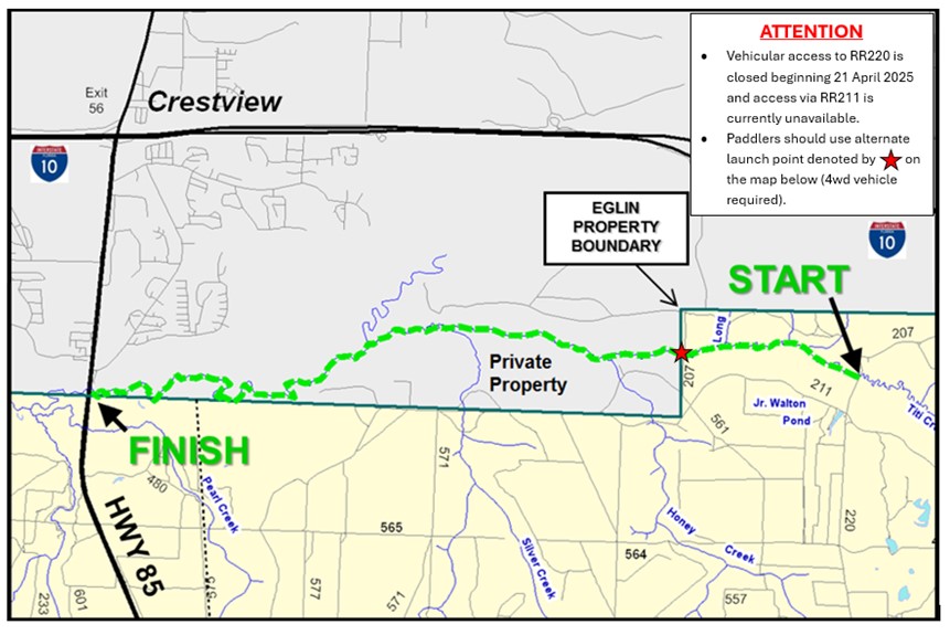
| Start: | Bridge on RR 220 |
| Take-out: | Bridge on Hwy 85 |
| Distance: | 9.5 mi |
| Estimated Time: | 6 hrs |
| Stream/River Width: | 15-25 ft |
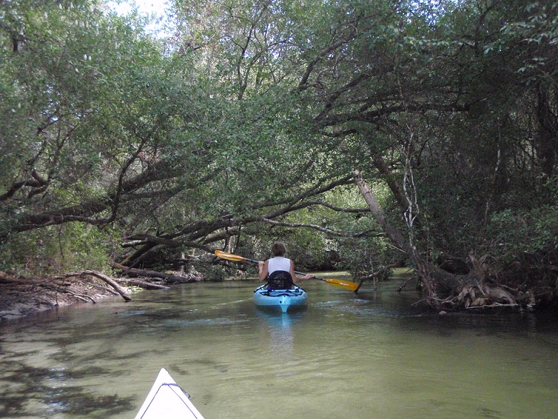
Turkey Creek
Arguably the most popular paddle trail on Eglin, Turkey Creek rises in the heart of Eglin and descends through picturesque gorges known as “steelheads” as it makes its way to Boggy Bayou in Niceville.
This twisting clear-water creek has multiple public access points. The most common and easiest to access put-in is at Gooden Bridge on RR 232 but you may extend the trip by 3 miles by putting in at the “Hippie Hole,” on RR 233.
Old cypress snags occur on either side of the creek and fallen trees and low-hanging brush are encountered occasionally along this trail. Rogue Creek enters Turkey Creek just south of the put-in. Still farther south, the Highway 123 bridge crosses the creek. Around the next bend, Juniper Creek enters from the east.
During the last 1.5 miles of the trip, the creek leaves the reservation and passes through land owned by the City of Niceville. This section contains a public park and boardwalk with swimming platforms. On warm weekends you will encounter many swimmers, many of whom are children and are slow to get out of the way. Exercise caution when passing through swimming areas. Pass under the concrete bridge in Niceville, and take out at Twin Cities Park boat ramp. The ramp is located behind a childcare center, next to the cement plant on HWY 20.
Click on the image to see a larger map:
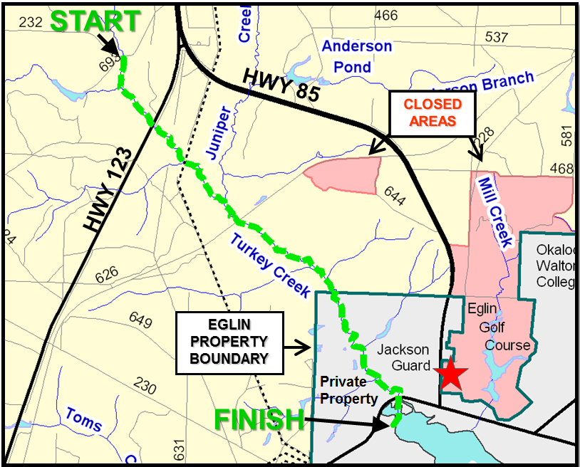
| Start: | Gooden Bridge on RR 232 |
| Take-out: | Chamber of Commerce Bldg, Niceville/Valparaiso |
| Distance: | 3.7 mi |
| Estimated Time: | 3 hrs |
| Stream/River Width: | 15-25 |
Start: Gooden Bridge, RR 232
Take-out: Chamber of Commerce Building, Niceville/Valparaiso
Distance: 3.7 mi
Estimated Time: 3 hrs
Stream/River Width: 15-25 ft
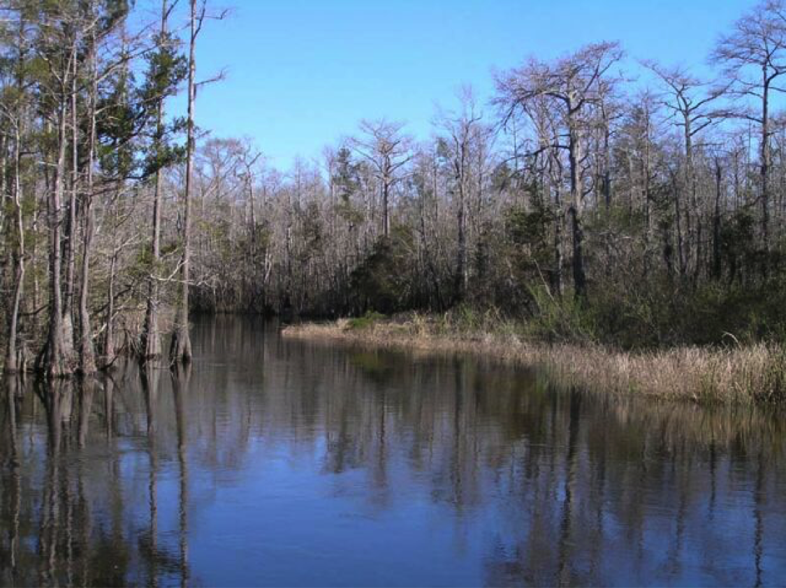
White Point
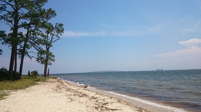
White Point, looking east.
Located adjacent to the Mid-Bay Bridge, White Point is an excellent location for practicing paddle skills prior to tackling Eglin’s more demanding paddle trails. That said, White Point is an open water location and good judgment should be exercised. This area is subject to high wind and waves at times. Strong currents and winds can easily blow even experienced paddlers away from the beach.
Despite its detached location near Niceville, this area is a part of Eglin AFB and visitors are required to possess a recreation permit. When visiting, park/drive only on designated roads and parking areas. Do not trample beach grass or other plants. Glass is strictly forbidden on all Eglin Beaches.
Paddle responsibly and leave no trace!
Last-minute Reminders:
- Certain areas are shown on the trail maps as “Closed Areas.” Entry into any closed area is prohibited. Some streams mark the boundary of a closed area. Paddlers should exercise great care in not stopping on the restricted bank of these streams.
- PLEASE pack out all the material/waste/trash that you pack in.
- NO GLASS or ceramic containers are allowed along paddle trails.
- Camping is only allowed at designated campsites with the proper permit.
- Campfires along paddle trails are only allowed at designated campsites with the proper permit.
- All occupants of the vessel must have a properly fitting personal flotation device.
- NO PETS are allowed on any Eglin paddle trails or adjacent beaches
- All Eglin waterways have poisonous reptiles and ALLIGATORS. Swim and paddle cautiously!